Andhra Pradesh’s rainfall fate has always danced to the rhythm of distant ocean currents, atmospheric wave trains, and powerful cyclones. From the deadly fury of the 1977 Diviseema storm to the game-changing 2014 Hudhud cyclone, history reveals a repeating cycle of dominance — sometimes driven by inland monsoon troughs, and sometimes by storms birthed deep in the Bay of Bengal.
But what happens when this cycle tilts too far in one direction?
In recent years, coastal belts like Kavali, Nellore, Tirupati, and even parts of Chennai have seen their dependency on cyclone-based systems skyrocket, as monsoon troughs weaken or vanish altogether. Rayalaseema, often left parched, feels this more than anyone. And with no strong Cat 4 or Cat 5 cyclone having “reset” the climate since Hudhud, the atmospheric balance remains tilted.
So — is there an end in sight to this cyclone dominance? Or are we just getting started?
Since the devastating landfall of Cyclone Hudhud in 2014, Andhra Pradesh (AP) has been locked in a cyclone-dominant rainfall pattern. With Rayalaseema increasingly relying on systems like depressions and cyclones for rain, a pressing question emerges: When will this pattern end?
To answer this, we studied 140+ years of data — from 1886 to 2025 — covering El Niño-Southern Oscillation (ENSO) phases, Pacific SST anomalies, Rossby wave activity, MJO behavior, and cyclone landfall records
📊 Historical Phases of Rainfall Dominance in AP
| Period | Dominant Pattern | Key Highlights |
|---|---|---|
| 1886–1910 | Cyclone-Dominant | Frequent cyclones, Rayalaseema drought-prone |
| 1911–1935 | Monsoon-Trough | More inland WMLs & LPAs |
| 1936–1949 | Cyclone-Dominant | Pre-1950 shift, stronger cyclones |
| 1950–1990 | Cyclone-Dominant (40 y) | Peak period with multiple Cat 3–5 landfalls |
| 1991–2013 | Trough-Dominant (23 y) | Steady Oct-Dec rainfall, good for Seema |
| 2014–Present | Cyclone-Dominant (11 y) | Post-Hudhud era, systems-based rainfall returns |
🌊 Pacific SST, ENSO & Rossby Wave Triggers
▶ Key Years with Warm-Water Shifts:
| Year | Niño-4 SST Anomaly | ENSO Phase | Cyclonic Activity Triggered? |
| 1974 | −0.4 °C | La Niña | Strong ridge setup (monsoon-dominant) |
| 1975 | −0.5 °C | La Niña | Continued monsoon-tough benefit |
| 1988 | −1.2 °C | Strong La Niña | Major Cat 5 cyclone in 1989 (Gay) |
| 2025 | +0.3 °C | ENSO-neutral | No significant ridge shift seen |
Note: SSTs in 1988 didn’t spike globally but created a huge east-west gradient that helped Rossby wave activation
🌀 Cat 4/5 Cyclones as Cycle-Breakers
| Year | Cyclone | Landfall Zone | Result |
| 1977 | Diviseema | Krishna-Guntur | Ended old cycle, triggered new one |
| 1989 | Gay | Kavali (Rare) | Marked end of 1950–90 era |
| 1990 | Super Cyclone | Machilipatnam | Reinforced end of cyclone phase |
| 2014 | Hudhud | Visakhapatnam | Triggered current cyclone-dominant era |
No Cat 4/5 landfalls occurred after 2014, hence no “breaker” has come.
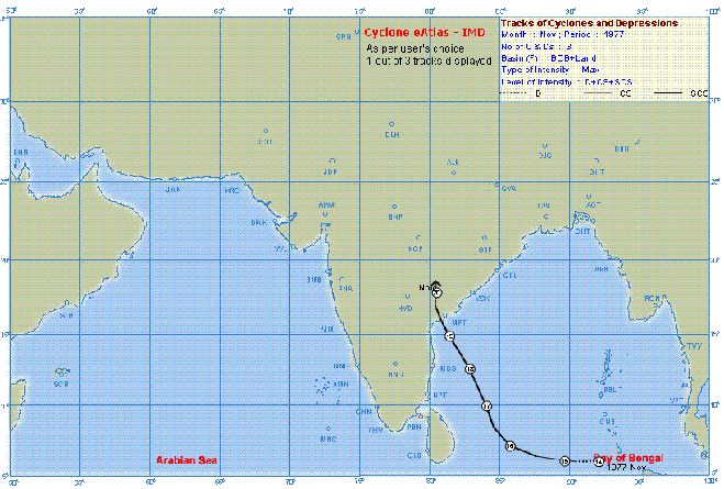
Diviseema 1977
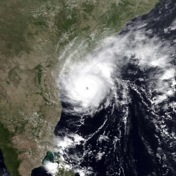
Cyclone Gay or Kavali
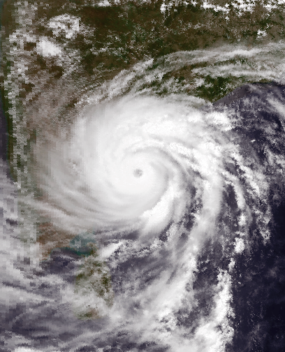
1990 Super Cyclone
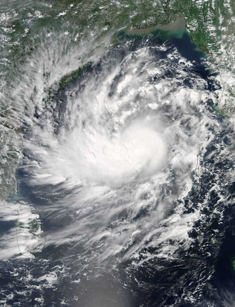
Hud Hud cyclone
🌪️ Cyclones Impacting Andhra Pradesh
| Year | Cyclone | Category | Landfall / Path | Notable Impact |
|---|---|---|---|---|
| 2005 | Pyarr | Normal | Kalingapatnam | Impact on NAP |
| 2006 | Ogni | Normal | Bapatla – Ongole | Rains all over coastal regions |
| 2010 | Jal | Normal | TN–AP border | Flooding in Nellore, Tirupati |
| 2012 | Neelam | Normal | Chennai–Nellore coast | Gusty winds, urban flooding |
| 2013 | Helen | Normal | Machilipatnam | Heavy rain, localized flooding |
| Lehar | Cat 2 | Weakened near Machilipatnam | Weak at landfall, moderate rain | |
| Madi | Cat 2 | Recurved, brushed TN–AP coast | Heavy rain in coastal AP & north TN | |
| 2016 | Roanu | Normal | Skirted AP coast | Coastal winds, moderate rainfall |
| Vardah | Cat 2 | Landfall near Chennai | Tirupati affected, trees uprooted | |
| Kynat | Normal | Touched Nellore coast | Impact only on Nellore | |
| 2018 | Titli | Cat 2 | Srikakulam | Major wind damage, hill flooding |
| Phethai | Normal | Kakinada | Widespread coastal rains | |
| 2021 | Gulab | Normal | Kalingapatnam | Entered Telangana, triggered Rayalaseema rainfall |
| 2023 | Michaung | Cat 2 | Nellore – Singarayakonda | Heavy flooding in Nellore, Singarayakonda; Chennai corridor affected |
These cyclones, while not Cat 4 or 5, still disrupted rainfall distribution and triggered urban flooding and coastal surge events.
🌬️ Present Indicators (2025)
| Parameter | Current Status | Effect on Phase End? |
| ENSO Phase | Neutral | No pressure to end cycle |
| Niño-4 SST | +0.3 °C | Far below 1988’s anomaly |
| Rossby Waves | Weak/Normal | No major inland steering |
| MJO | Disorganized | No tropical rain advantage |
| Cat 4/5 Cyclones | None (post-2014) | No atmospheric reset |
🔄 Present‑vs‑Past Indicator Snapshot
| Metric | Peak Cyclone Stretch(1987–1990) | Current Stretch(2021–2025) |
| ENSO phase | Mostly La Niña (−0.8 to −1.5 °C) | Neutral / weak La Niña (−0.1 to −0.4 °C) |
| Niño‑4 gradient | Strong west–east (+1 °C vs east) | Mild (+0.3 °C) |
| MJO activity | Repeated strong phases in Oct–Nov | Disorganized, low amplitude |
| Rossby wave train | Pronounced, steering ridge inland | Weak, ridge near coast |
| Cat 3+ landfalls on AP | ’87 moderate, ’89 Cat 5 Gay, ’90 Cat 4 | None (post‑Hudhud) |
| Rayalaseema Oct‑Dec mean rain | 110–130 mm (1987–90 avg) | 75 mm (2021–24 avg) |
📅 Cyclone Tally by Year (Current Era vs Late‑80s)
| Year | Cyclones Impacting AP (≥Depression) | Category | Landfall / Track |
| 1987 | 2 | SCS | Brushed Vizag (Oct) |
| 1988 | 3 | 1 Cat 3 | One Odisha landfall; heavy AP rain |
| 1989 | 1 | Cat 5 (Gay) | Direct Kavali hit (Nov) |
| 1990 | 2 | Cat 4 | Vizag (May) + DD in Nov |
| 2021 | 4 | 0 | Series of DD/WML Oct–Dec |
| 2022 | 2 | 0 | One DD in Nov, one LPA Dec |
| 2023 | 3 | Cat 1 (Michaung) | Bapatla landfall (Dec) |
| 2024 | 2 | TS (May Pondy) | Skirted Nellore, Oct LPA |
| 2025 | 0 | 0 | No cyclonic systems recorded |
*2025 still in progress. No cyclonic systems (≥DD) have made landfall or caused notable impact in Andhra Pradesh so far — marking it as a rare lull year in an otherwise cyclone-dominant era.
Key Take‑aways:
- Intensity gap: Late‑80s produced two Cat 4/5 in four years; current window has had none since 2014.
- Steering difference: ’87–90 Rossby setup pulled storms inland; 2021–25 ridge still hugging coast.
- Rainfall outcome: Rayalaseema averaging ≈30 % less Oct‑Dec rain now than in the late‑80s peak.
🧭 Conclusion: When Will Cyclone Dominance End?
❌ Not Yet.
All data shows we are still early in the current cyclone-dominant era:
- Historically these phases last 25–40 years
- We’re only 11 years into the post-Hudhud system pattern
- No El Niño, SST spike, or Cat 5 cyclone has yet appeared to end it
Prediction: Unless a Cat 4/5 cyclone hits AP, or a super El Niño emerges (like 1997 or 1982), this phase will likely extend into the mid-2030s or beyond.
💧 Why Rayalaseema Gets More Rain in Monsoon‑Dominant Years
- Trough residence time: LPAs/WMLs linger 2–4 days over Deccan plateau.
- Steering ridge position: Arabian ridge extends to Ongole, pushing systems inland.
- Lower shear: Weak vertical wind shear lets cloud bands spread far west.
- Repeated spells: Multiple small systems vs one big cyclone equals better soil moisture & groundwater recharge.
📌 Implications for Rayalaseema & Coastal AP
- Expect short, intense bursts of rainfall via cyclones
- Long dry spells between systems will persist
- Rayalaseema remains drought-prone unless system tracks shift westward
- Agri-policy must adapt to cyclone-reliant rainfall and water storage models
☀️ Special Focus: Effect on Rayalaseema
The cyclone-dominant era has had mixed but mostly negative consequences for Rayalaseema:
- Monsoon troughs and inland WMLs, common during 1991–2013, brought consistent, widespread rains that benefited agriculture.
- In contrast, post-2014 cyclones often move along the coast, missing interior districts like Anantapur and parts of Chittoor.
- Anantapur and Kadapa are especially vulnerable, receiving little benefit unless cyclones curve westward.
- Short-duration, high-intensity rains from cyclones lead to flash floods, but poor groundwater recharge.
- Tirupati region, though slightly better placed, still faces erratic rainfall and growing flood risk.
Key impacts:
- Increased drought frequency since 2014 in interior Seema
- Uneven rainfall distribution year to year
- Irrigation stress due to poor water retention
- Flash floods in urbanized zones like Tirupati and Kadapa
🌟 Final Word: What We’ve Learned
The atmospheric history of Andhra Pradesh tells a story of cycles — decades dominated by either the mighty hand of tropical cyclones or the quiet but steady march of the monsoon trough. Right now, we are still within the cyclone-dominant chapter, marked by abrupt, intense rain spells and long, thirsty pauses in between.
But change is never far.
Whether driven by a future Cat 5 landfall, an unexpected super El Niño, or a rare monsoon resurgence, the tipping point will come. The data suggests it won’t be immediate — but the transition will be dramatic when it does.
And when that moment arrives, it may redefine how AP prepares, plants, stores water, and predicts the sky.
📌 For Rayalaseema, the key lies in balance — not just between storm and calm, but between preparation and adaptation.
Thanks to Akshay for sharing historical information of cyclones
Stay tuned. The next Cat 4/5 could change everything.
📚 Sources & References
- India Meteorological Department (IMD): https://mausam.imd.gov.in/
- NOAA ENSO Data (CPC): https://www.cpc.ncep.noaa.gov/
- JTWC (Joint Typhoon Warning Center) Cyclone Reports
- EM-DAT Disaster Database: https://www.emdat.be/
- Japan Meteorological Agency (JMA) SST archives: https://ds.data.jma.go.jp/tcc/tcc/products/elnino/
- Indian National Centre for Ocean Information Services (INCOIS): https://incois.gov.in/
- Pacific SST datasets via NOAA ERSSTv5: https://psl.noaa.gov/data/gridded/data.noaa.ersst.v5.html
Compiled with data from NOAA, JMA, IMD, and historical cyclone records.